


EXCLUSIVE| First Egyptian scientific research proves the pyramids possess earthquake-resistant technology
Discovery of the pyramid fields documents periods of climate shift and the pre-flood era

Cairo – Amr AbduLRahman – Exclusive to [AISC News]
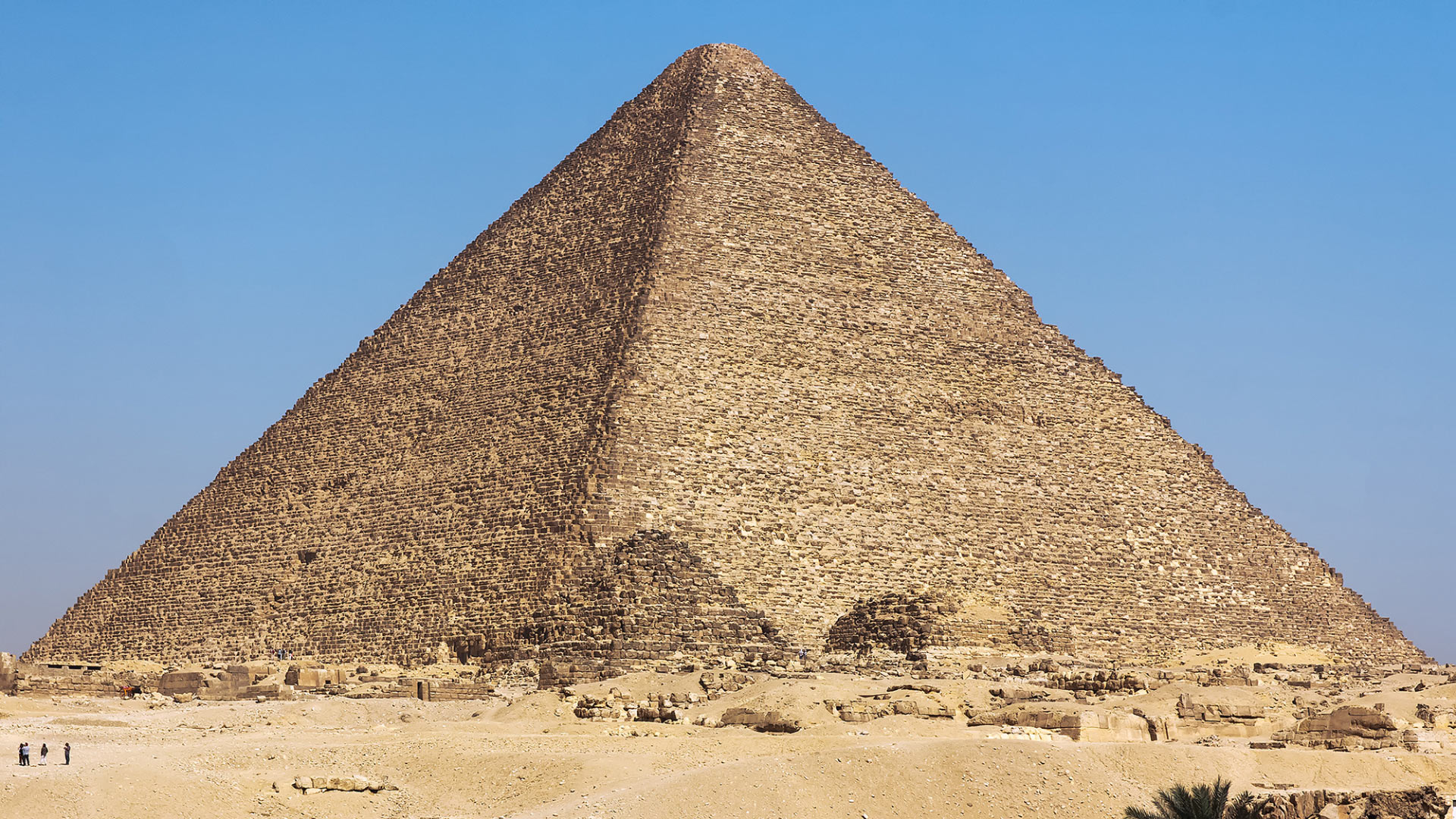
For over 4,500 years, the Great Pyramid of Giza has stood proudly on the Giza Plateau, withstanding dozens of earthquakes without suffering significant structural damage.
Based on this, new research, led by the National Research Institute of Astronomy and Geophysics in Egypt, has emerged, offering a quantitative explanation for this remarkable resilience.
It showed that the pyramid’s natural resonant frequencies differ significantly from those of the surrounding ground, a difference that may have helped the monument avoid destructive resonance during earthquakes.
It revealed how it withstood numerous earthquakes, including a 6.8 magnitude quake in 1847 and a 5.8 magnitude quake in 1992, without sustaining significant damage, either externally or internally.
Dr. Assem Salama, the study’s lead author, and his colleagues from Egypt and Japan stated, “The Great Pyramid of Giza (Khufu’s Pyramid) was the oldest pyramid built in the northwestern part of Egypt, standing at 146.59 meters tall, with a base length of approximately 230.33 meters per side and an angle of inclination of 51 degrees.”
Current measurements indicate that the pyramid’s current height is approximately 137 meters, reflecting the loss of its original casing stones and apex over time.
The pyramid’s structure consists of a core and a casing of horizontal stones, interspersed with supporting blocks.
The Great Pyramid of Giza contains 2.3 million stone blocks, each meticulously placed to achieve its immense size and stability. This elaborate design showcases the architectural prowess and advanced engineering planning that characterized the Egyptian pyramid builders.
In their new research, the researchers recorded seismic noise at 37 locations within the pyramid.
Most parts of the pyramid have a remarkably stable fundamental frequency ranging between 2 and 2.6 Hz, while the surrounding soil vibrates at approximately 0.6 Hz.
This separation likely reduces the risk of seismic amplification of vibrations within the pyramid itself.
The researchers also found that vibration amplification increases upwards within the pyramid but decreases in the stress-relieving chambers above what is metaphorically called the King’s Chamber, suggesting that these spaces may help dissipate seismic stress [1].

☀ _____ Pyramid Fields on the Ancient Branches of the Nile in the Western Desert _____
On the other hand, archaeologists have previously discovered the remains of an extinct branch of the Nile River, 64 kilometers long, which they named the Pyramid Branch. It flows at the foot of the Western Desert plateau, where the majority of ancient Egyptian pyramids are located.
Many of these pyramids are connected by causeways leading to this branch and ending at valley temples that may have served as river ports along its course in the past.
Sedimentary evidence indicates that the Nile River had a much higher flow in the past, branching into several distributaries that extended through areas that have turned into desert thousands of years ago.
The study, led by Dr. Iman Ghoneim, a professor at the University of North Carolina at Wilmington, and her colleagues, used satellite imagery to pinpoint the location of the ancient branch at the foot of the Western Desert plateau, near the pyramid fields.
The researchers used geophysical surveys and sediment samples to confirm the presence of ancient river deposits and channels beneath the current surface, indicating the existence of an ancient river branch, which they proposed to name the “Pyramid Nile.” They found that many pyramids had causeways that terminated at the banks of this ancient river.
They revealed that sand accumulation associated with ancient desertification was one of the reasons for the branch’s eastward migration—and the eventual accumulation of silt within it.
This discovery explains why these pyramid fields were concentrated along this desert strip near the ancient Egyptian capital [Memphis] – “Memphis” in Greek – making the capital strategically and geographically important [2].

☀ _____ The Climate Shift, the Black Carpet Era, and the Great Flood _____
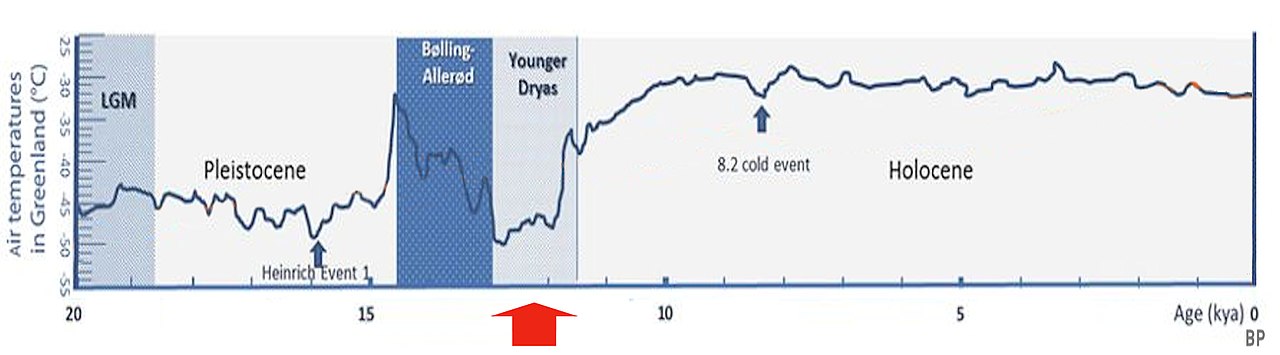
It also sheds light on how human society has historically been affected by environmental and climatic changes, especially during the Younger Dryas (or Little Ice Age), which saw severe climatic shifts with widespread and intense droughts affecting various regions around the world, beginning 12,900 years ago and lasting for approximately 1,300 years.
This global drought was linked to several key factors and effects, including:
First, Monsoon Disruption: The sudden cooling in the Northern Hemisphere weakened monsoon systems (such as those in Africa and Asia), causing a sharp decline in rainfall and severe continental drought, as well as the drying up of major rivers upon which great civilizations thrived.
Second, Vegetation Change: Vast areas of forests and green grasslands were transformed into semi-arid regions or deserts due to decreasing temperatures and humidity.
Third, Water and Food Shortages: The drought placed immense pressure on natural resources, ultimately leading to the start of the great migrations of the late Copper Age and early Bronze Age.

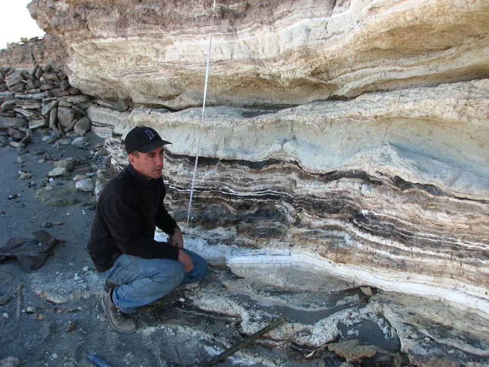
The study links the Pleistocene and Holocene epochs (the last glacial melt period) and includes 97 archaeological sites, two-thirds of which contain a layer of black soil rich in organic matter called the “Black Mats.”
This is a carbon-rich sedimentary layer widespread throughout North and South America, coinciding with the transition from the Pleistocene to the Holocene.
The Black Mats geological layer was deposited from the beginning to the end of the Pleistocene, and its radiocarbon dating indicates that it is contemporaneous with the Younger Dryas period.
It preserved the last remains of the megafauna that became extinct at the end of the Pleistocene epoch, catastrophically, coinciding with the Great Flood.
The “Black Mats” represent a landmark of the Late Ice Age and are geologically and archaeologically linked to the abrupt climate shift that occurred during the Younger Dryas period approximately 12,900 years ago.

This layer also marks the boundary between two epochs:
- The Rancholabrean Period
- The Clovis Period
First, the Rancholabrian Period extended from 190,000 years ago until the end of the Pleistocene epoch (12,000 years ago). It is renowned as the golden age of megafauna (such as mammoths, bison, mastodons, giant ground sloths, saber-toothed tigers, coyotes, and Native American horses), which roamed the continents. Their extinction coincided with the end of the last Ice Age.
Second, the Clovis Period saw the emergence of the first widespread human culture in the Americas after the Flood. It lasted for approximately 300 years, and the Clovis people are considered the first to cross the Bering Land Bridge from the far north of Eurasia to the Americas.
The “Pre-Clovis” theory has recently evolved, with other archaeological sites in the Americas, such as Monteverde in Chile and the Paisley Caves in the United States, demonstrating human settlement dating back thousands of years before the Clovis culture.
.
.
☀ Source – Link [PDF]:-
.
.
.
Younger Dryas ‘‘Black Mats’’ and the Rancholabrean termination in North America https://www.pnas.org/doi/pdf/10.1073/pnas.0800560105
.
Partin, J.W.; Quinn, T.M.; Shen, C.-C.; Okumura, Y.; Cardenas, M.B.; Siringan, F.P.; Banner, J.L.; Lin, K.; Hu, H.-M.; Taylor, F.W. (2 September 2015). “Gradual onset and recovery of the Younger Dryas abrupt climate event in the tropics”. Nature Communications. 6 8061. Bibcode:2015NatCo…6.8061P. doi:10.1038/ncomms9061. PMC 4569703. PMID 26329911.
Johnson, M.D.; Öhrling, C.; Bergström, A.; Dreyer Isaksson, O.; Pizarro Rajala, E. (2022). “Geomorphology and sedimentology of features formed at the outlet during the final drainage of the Baltic Ice Lake”. Boreas. 51 (1): 20–40. Bibcode:2022Borea..51…20J. doi:10.1111/bor.12547. ISSN 0300-9483.: 20
.
_____
.
☀ References:
(1)
Leading Research Source:
National Research Institute of Astronomy and Geophysics in Egypt
The research team’s paper was published in the journal “Scientific Reports” – “Communications Earth and Environment” on May 21, 2026.
Research conducted by: Mohamed El-Gabry – Title:
Architectural and Geotechnical Aspects Affecting the Earthquake Resistance of the Ancient Egyptian Pyramid of Khufu.
Scientific Reports 16, 14032; doi: 10.1038/s41598-026-49962-6
.
The team’s findings were published on May 21, 2026 in the journal Scientific Reports.
- ELGabry et al. 2026. Architectural and geotechnical aspects affecting earthquake resilience for the antique Egyptian Khufu pyramid. Sci Rep 16, 14032; doi: 10.1038/s41598-026-49962-6
____
(2)
Dr. Eman Ghoneim et al., 2024.
The Egyptian pyramid chain was built along the now-abandoned Ahramat Nile branch. Communications Earth & Environment, 5, 233; doi: 10.1038/s43247-024-01379-7
The team’s paper was published in the journal Communications Earth & Environment.
- Ghoneim et al. 2024. The Egyptian pyramid chain was built along the now abandoned Ahramat Nile branch. Communications Earth & Environment 5, 233; doi: 10.1038/s43247-024-01379-7